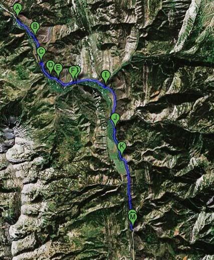
I'll be periodically updating this post with the location of the Cuttie-Thoners. The links are to Google Maps. If you haven't used this before, click the "Satellite" button in the upper right hand side of the window to see a photo of the terrain.
At 7:00 this morning, they were here:
+42° 59' 36.96", -110° 47' 9.60" or 42.9936,-110.786
At 9:00 they had moved 0.9 miles and were here:
+42° 59' 0.24", -110° 46' 32.88" or 42.9834,-110.7758 Quote; "wow this is a hike, but we're still alive!"
At 10:00, they had moved a total of 1.9 miles and were here:
+42° 58' 17.04", -110° 46' 13.08" or 42.9714,-110.7703
At 11:00, they had moved a total of 2.4 miles and were here:
+42° 57' 48.24", -110° 45' 52.56" or 42.9634,-110.7646The 12:00 update has them a total of 2.8 miles up and they were here:
+42° 57' 42.12", -110° 45' 36.00" or 42.9617,-110.76The 1:00 update has them 3.3 miles upriver and located here:
+42° 57' 42.48", -110° 44' 50.64" or 42.9618,-110.7474At 2:00 they are slowing down (pimento cheese time?). They are 3.5 miles up the river and located here:
+42° 57' 45.00", -110° 44' 43.80" or 42.9625,-110.7455I have a few updates to catch up. I've received waypoints at 3:30, 4:00, 5:00, 6:00, 7:00, and 7:45.
The last location at 7:45 was
+42° 53' 18.24", -110° 42' 28.44" or 42.8884,-110.7079. They have fished their way up 9.9 miles of river.
10:00, I haven't received any updates for a couple hours. I'm pretty sure Cameron and Mike were scheduled to attempt the entire 26.6 mile length of river. News when and if I get some ...
Tom